Links
Several space-geodetic observation techniques are used to determine the geodetic parameters related to the Earth, which are the Celestial Reference Frame (CRF, fixed to inertial space), the Terrestrial Reference Frame (TRF, fixed to the Earth’s body), the Earth Orientation Parameters (EOP) as the transformation between CRF and TRF, the Earth’s gravity field as well as tropospheric and ionospheric parameters. Depending on the observation principle, each of the space-geodetic techniques is sensitive to a different sub-set of these parameters.
Global Navigation Satellite Systems (GNSS) determine satellite orbits, EOP (polar motion offsets and rates, LOD, nutation rates), station coordinates for the TRF, low-degree Earth’s gravity field coefficients, the geocenter and parameters of the troposphere and the ionosphere. As satellite techniques, GNSS are not sensitive to the UT1-UTC and nutation offsets. Since ITRF2020, GNSS contribute to the realisation of the TRF scale as antenna patterns have been calibrated in advance. GNSS operations and analysis are coordinated by the International GNSS Service (IGS).
Doppler Orbitography and Radiopositioning Integrated by Satellite (DORIS) determines similar parameters like GNSS and contributes to the determination of the station coordinates for the TRF. DORIS operations and analysis are coordinated by the International DORIS Service (IDS).
Satellite Laser Ranging (SLR) determines similar parameters like DORIS and GNSS, excluding the ionospheric parameters, and contributes to the determination of station coordinates for the TRF. It is the only technique that allows to determine the geocenter, i.e., the defined TRF origin, with high accuracy, and contributes to the realisation of the TRF scale. Moreover, Lunar Laser Ranging (LLR) provides Moon orbits for the CRF realisation. SLR and LLR operations and analysis are coordinated by the International Laser Ranging Service (ILRS).
Very Long Baseline Interferometry (VLBI) is the only technique that determines quasar positions for the CRF and is sensitive to the full set of EOP (i.e., the complete transformation between the CRF and the TRF), including the UT1-UTC and nutation offsets. VLBI determines station positions for the TRF and contributes to the realisation of the TRF scale. However, VLBI currently determines neither satellite nor Moon orbits and is thus not sensitive to influences of the Earth’s gravity field. VLBI operations and analysis are coordinated by the International VLBI Service for Geodesy and Astrometry (IVS).
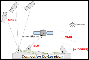
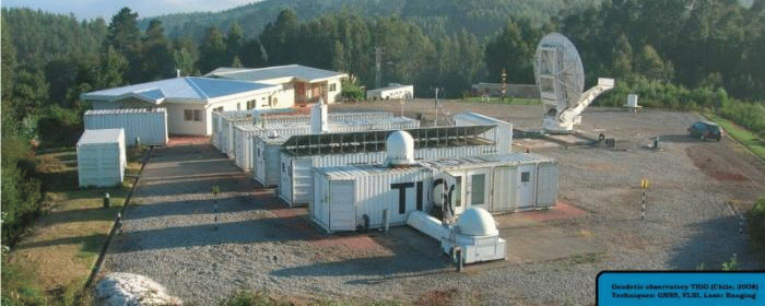
To exploit the capabilities of the space-geodetic techniques in combined solutions for TRF, EOP and CRF, the technique-specific station networks are connected by co-location sites. Therefore, all space-geodetic techniques form part of the Global Geodetic Observing System (GGOS) and the generation of the EOP and TRF products is organised within the International Earth Rotation and Reference Systems Service (IERS).
Co-location site