Station Coordinates - ITRF 2014
The ITRF2014 contributed data files of the 24h VLBI session are formatted in SINEX file format. All files containing datum free normal equation with station coordinates and Earth Orientation Parameter (EOP). To indicate the quality of the contribution, a WRMS is calculated for each or for all stations.
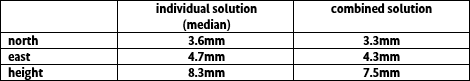
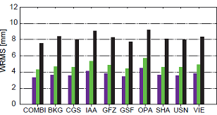 The overall WRMS from the session-wise analysis over all stations and for all ACs as well as the combined solution are 3-4mm for the north (violet), 4-6mm for the east (green) and 7-9mm for the height (black) component over all stations, see WRMS graphic.
Comparing the individual solution to the combined solution, the combined solution is more precise in evidence.
The overall WRMS from the session-wise analysis over all stations and for all ACs as well as the combined solution are 3-4mm for the north (violet), 4-6mm for the east (green) and 7-9mm for the height (black) component over all stations, see WRMS graphic.
Comparing the individual solution to the combined solution, the combined solution is more precise in evidence.
 The contributed ITRF2014 results (differences to the mean value) of the station coordinates are shown graphically in X,Y,Z and North, East, Up.
The file download open up the combined values of the absolute coordinate and the referred sigma with their mjd of the selected station.
The contributed ITRF2014 results (differences to the mean value) of the station coordinates are shown graphically in X,Y,Z and North, East, Up.
The file download open up the combined values of the absolute coordinate and the referred sigma with their mjd of the selected station.